

Expand and view sections required
We build raster chartsets for Marine Navigator on Android. We also make charts for a specialist app... qtVlm, Android or iPad. We do not currently support any other MOBILE apps, but support many programs (like OpenCPN) with Windows compatible charts
Marine Navigator is an app developed by Mr Ronald Koenig and was in Google Play for 10 years+ NOW we have it here. It is a fully functional chartplotter app, that uses standard free raster charts (KAP files) available for certain areas, like the USA and Brazil. The app can also use encrypted chartsets making available licensed copyright charts for the UK and other areas. Marine Navigator comes with no pre-installed charts, and costs £8.65 with AIS capability
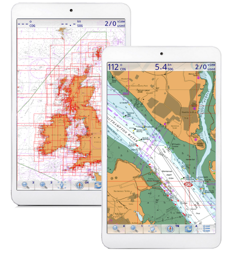
When used with appropriate charts, the app can be used as a stand alone portable chartplotter using the Android tablets' built in GPS (and compass if present). Routes, waypoints and tracks can be used and saved. Charts can be dragged around and switch automatically on zooming in/out.
A new easy chart activation system has been developed for VMH encrypted chartsets with activation codes provided on purchase. Chart purchases / downloads, installation & unlocking are always totally outside of Google Play Store infrastructure for free or paid chartsets.
Why use an Android tablet ?
Because if you get a decent tablet with 10" screen , and built in GPS and compass using these charts in conjunction with "Marine Navigator" app (buy for about £6.50 in the Google Play Store) will give you a fully featured chart plotter, that's "stand alone" and complete. No connecting GPS sets, it's all there already. The charts are fully installed, no internet needed (after installation) , use at sea. Use in the cockpit or chart table. You can get waterproof protective cases for the tablet too. Long battery life, quick start up... what more could you want ? (This ALSO works really well on phones.. great for quick reference in the cockpit)
Why "Marine Navigator" ?
Because we've found it to be so easy to actually use in real seagoing situations. The designer Ronald Koenig, is responsive and continues to update his app all the time. It's versatile.. In addition to our encrypted charts, it can also use standard BSB2/3 charts you may already have. For instance Antares charts for W. Scotland. This app can even calculate routes using Great Circle (for ocean sailors) or Rhumb lines.
"Marine Navigator is an offline navigator using raster navigational charts (RNC's) to plot your position in real time. This way you can navigate with true copies of official paper charts on your mobile device. This full version of the Marine Navigator provides besides the functionality of the lite version the following enhanced functions:
* automatic chart switching depending on current position and zoom level
* scrolling through all charts available for the current location by "press and hold" zoom buttons
* display of number of available charts for current location in the zoom buttons
* display of outlines of installed charts in active chart
* chart rotation (True North, True Course, Compass Heading, original chart orientation)
* tracks, way points, routes
* follow route automatically
* intuitive route editor
* gpx import and export of waypoints and routes
* gpx export of tracks
* recording of tracks in active and standby mode
* length of recorded tracks only limited by the capacity of the external storage (SDCARD)
* compass (magnetic north, true north)
* different dashboard layouts (basic data, detailed route data, detailed GPS data including graphical status info)
* Man Over Board (MOB) functions"
AIS screenshots
This example is using an underlying map, not a chart:
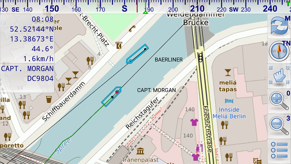
In this picture above both vessels have send position reports and static voyage related data (name of vessel, call sign, ...). The black dots show the last received position. The black lines show the predicted course. The position of the vessel is calculated based on the data of the last received position report (position, COG, SOG). The dimensions of the vessels are taken from the last received static voyage related data report. Capt. Morgan is selected therefore its detailed data are shown in the upper left corner of the screen and its track based on the previously received position reports is shown by a green trailing line. Capt. Morgan has not specified its destination. Therefore destination information is missing below the call sign.
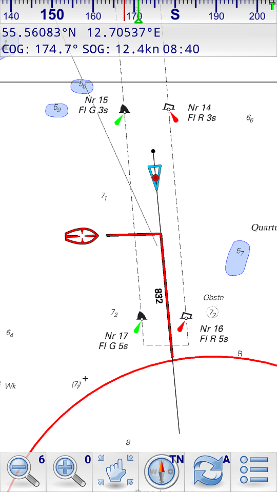
This picture above shows a collision alert. The red line on the own course line shows the passing distance when the other vessel crosses the own course line. The red line on the course line of the AIS target shows the passing distance when the own vessel crosses the course line of the AIS target. In the illustrated case the own vessel will cross 832m behind the AIS target. The AIS target (red cursor) is selected. It hasn't send any static voyage related data yet. Therefore only data of the position report is shown (position, SOG, COG).
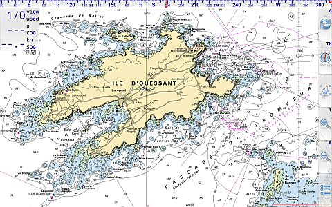
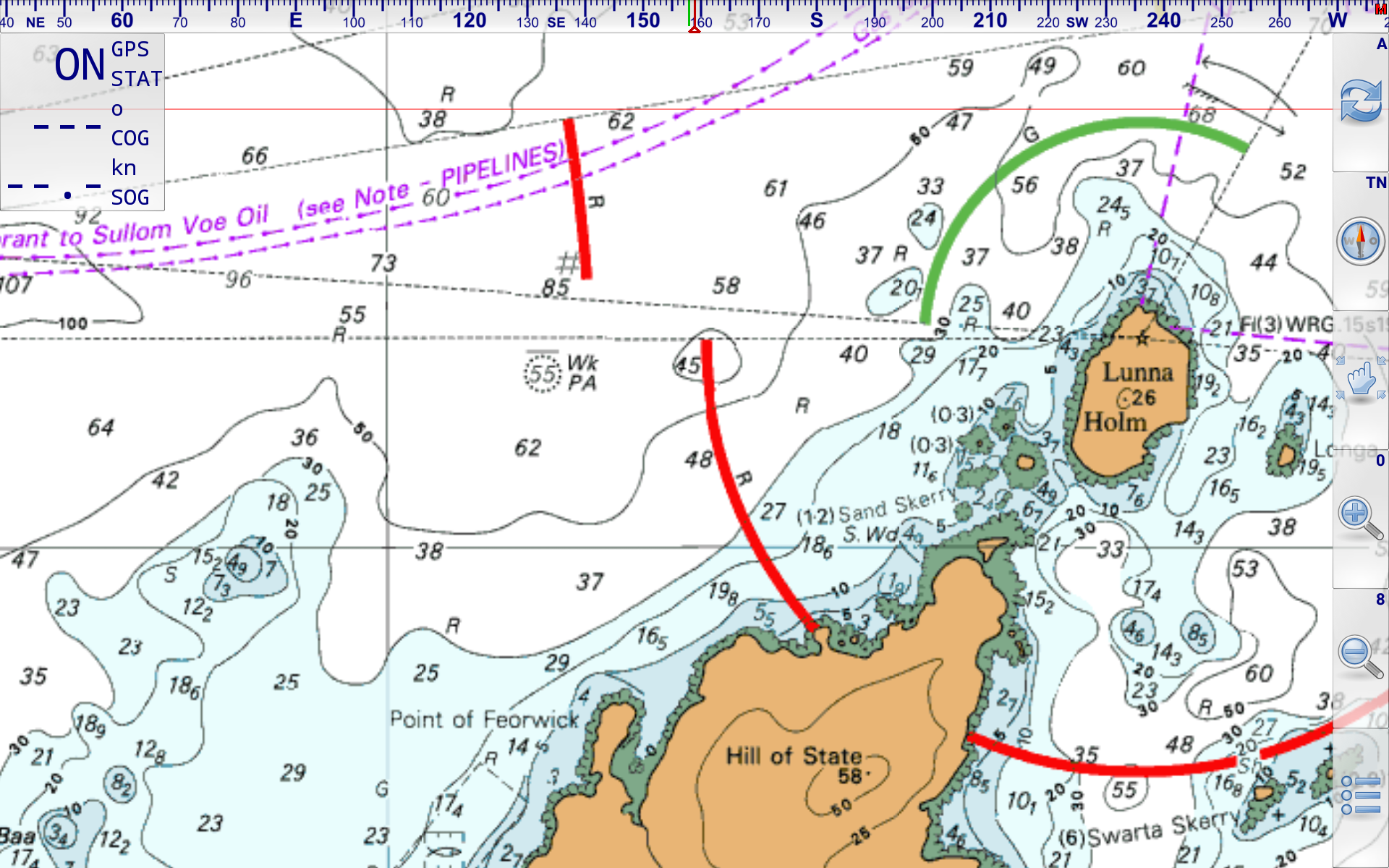
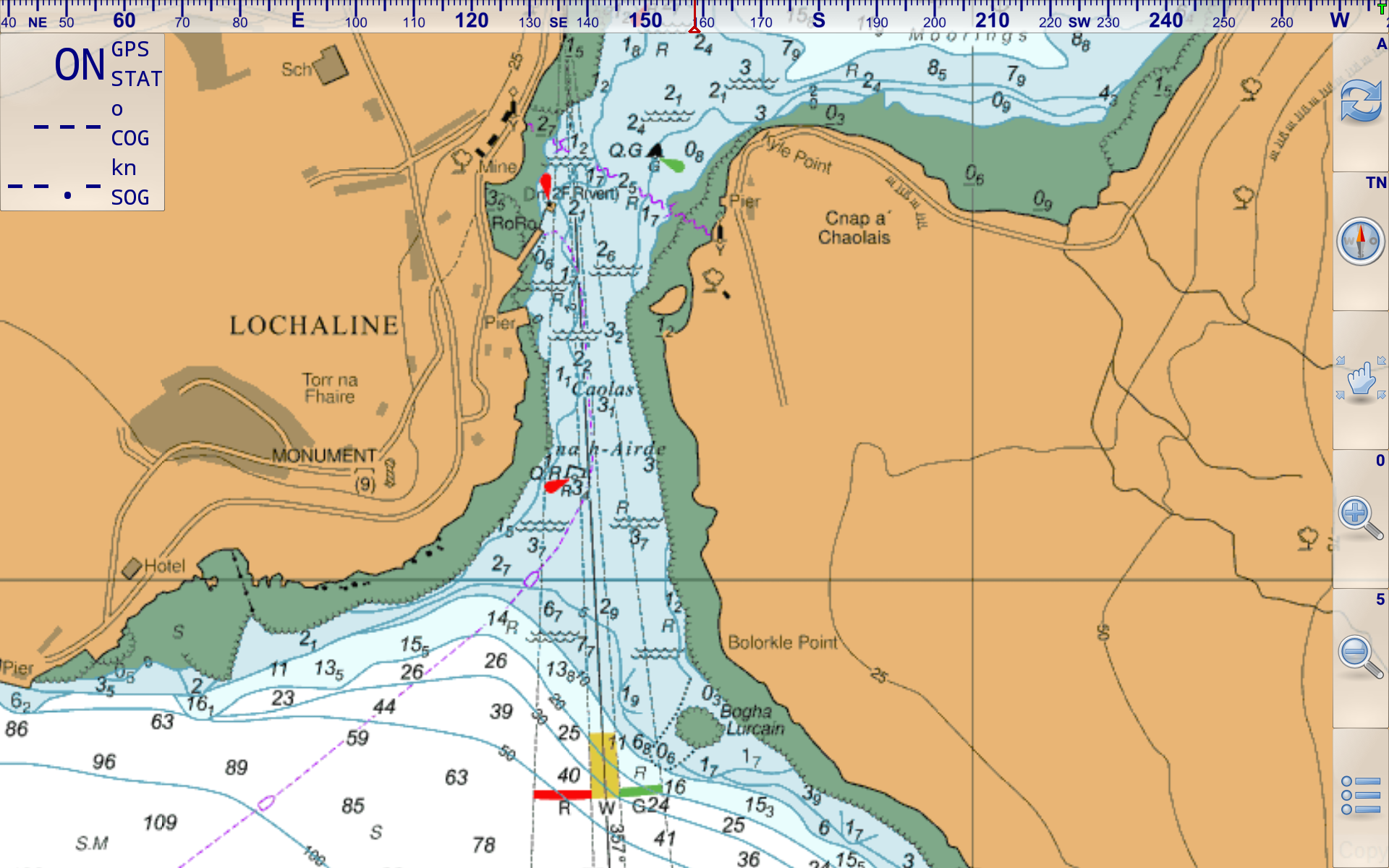
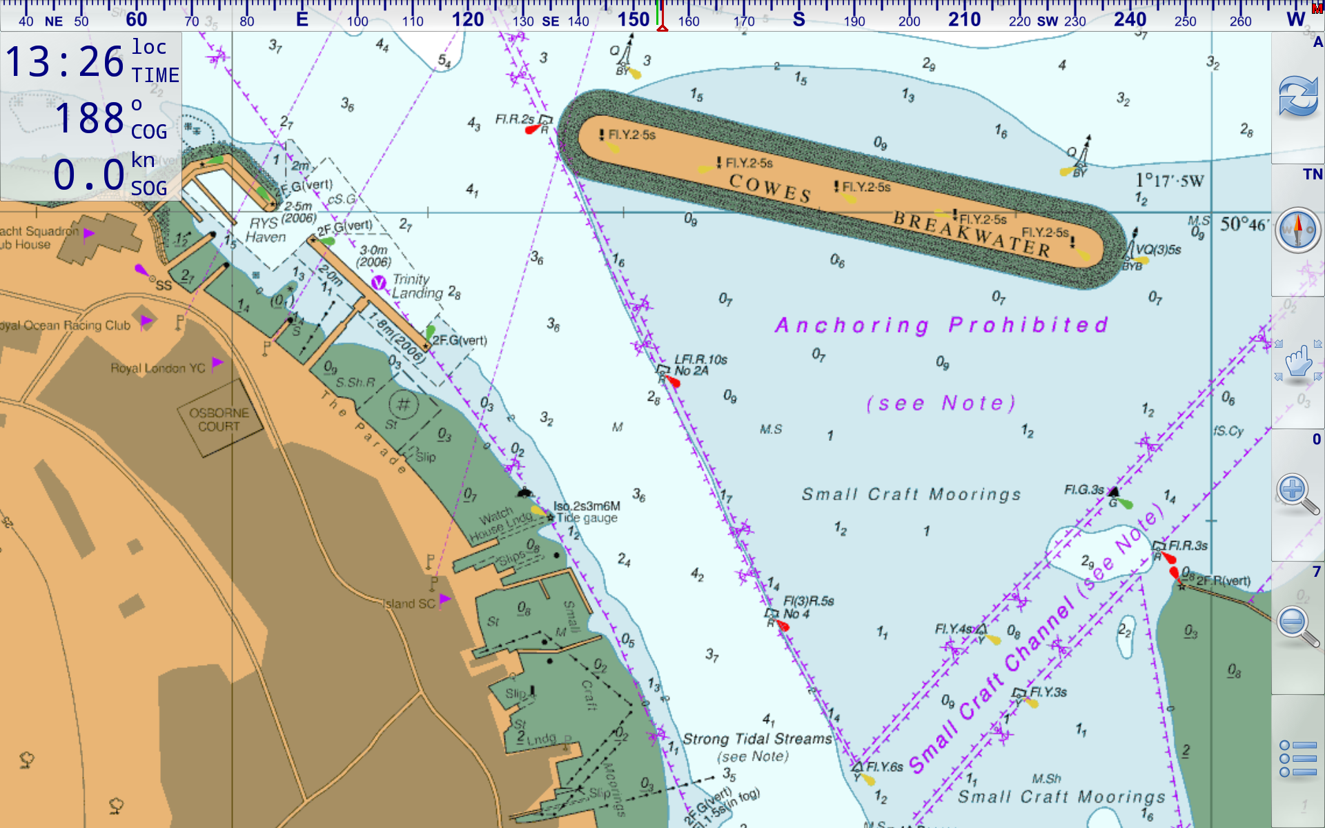
Made from standard raster charts. You just can't beat the superb detail of raster charts. Vector charts do not have the richness of detail, but are seamless. At VMH we prefer raster every time.
Tap/Click thumbnails to see large image

Tap/Click thumbnails to see large image


Tap/Click thumbnails to see large image
This is a "buy and keep" product NOT a subscription of any kind
Chart dates: UK-IRL -BE-NL-ES-PT all 1st Jan 2025 & French Charts December 2024.
Choose and buy/download your chosen coverage:
(New 2025 coverage areas and members discount structure)
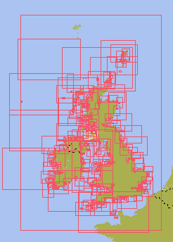
UK and Ireland 2025
.
.
This 2025 UK/Ireland edition contains over 826 raster charts.
£17 for non members ( 870 Mb )

One update during 1st year of purchase
.
.
Important note: Although the French coasts are visible, there is not enough detail to approach these coasts safely. If visiting France you WILL need the package below:.
.
..
.UK and Near Continent 2025 (added French coverage)
.
.
.
.
.
This Channel France/UK/Ireland/Belgium/Netherlands edition contains over 1100 charts Coverage: UK/Ireland/Channel and Atlantic France/ Belgium, 100% at all scales available. French coverage at all available scales, starts at Belgium extends to Spanish Border. Beautiful SHOM French charts.
£38 for non members (1.36 Gb)
One update during 1st year of purchase
For the avoidance of doubt: Our Netherlands coverage in this and any other product is shown below:
![]()
.No freshwater inland coverage. Fine for coastal passagemaking.
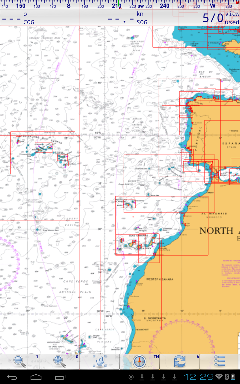
Spain, Portugal, & Atlantic 2025 (ES-PT-AT)
Free bonus: 20+ Atlantic planning charts included
.

NEW Spain, Portugal, and Atlantic planning:
* Wide area coverage *
* inc. detailed coverage of Maderia, Azores, Canary Islands and Cape Verde islands*
* inc. All major Ports and Harbours within Spain and Portugal waters
* All UKHO raster charts available covering mainland Spain and Portugal, plus Balearic Islands, 226 charts*
* Suitable for those setting off from the West Country to Spain and the Med, or to the Azores, Canaries, etc* .
CLICK IMAGE for more info
£42 for non members
(1.86 Gb)
One update during 1st year of purchase
For the avoidance of doubt, this package covers in detail all major Ports and Harbours within Spain and Portugal waters, plus the Atlantic islands, inc Cape Verdes. It DOES NOT contain detailed chartlets of every small craft harbour/marina on these coasts. Used for passage-making with calls at major harbours (eg La Coruna, Lisbon, Palma, Ibiza, Santa Cruz de Tenerife, etc etc), this chartset is fine. Used in conjunction with a decent pilot book with chartlets it's fine for a proper and deep exploration of these areas.
.
Includes...Atlantic Planning Charts (this set is already bundled with the set above )
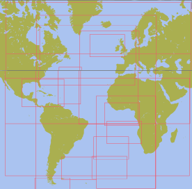
This set of 22 Charts at very small scale, cover the whole North and South Atlantic Oceans. It enables TransAtlantic planning, and ties in nicely with the set above.
.
.
.
The whole process to install our Marine Navigator charts has been simplified.. the best way is look at the screenshots below.
It's important to have the latest version of Mr Koenigs' app (2.1.14 or newer the one with AIS trial).. Auto activate won't work on older versions of the app.
Estimated times involved.
1. Pay using shopping cart, and receive receipt on tablet, write down one unlock code: 5 mins
2. Download the chartset direct to the tablet: 5mins- 20mins ...Depends on your broadband speed.
3. Import charts into app and activate: 10-30 mins.. Depends on size of chart set & speed of machine
Whole process 20-60 mins odd if you have broadband. Internet not required once the charts are activated and working
Firstly: Pay on shopping cart, collect receipt email on target tablet, and then download chart set. (Important note: The email address you put in the shopping cart is the one the download/unlock receipt will be sent to automatically. It will appear to come from VisitMyHarbour Sales Dept, from a gmx.com email address. Check your spam box if you don't get it within 5 mins.)
The receipt email from the cart looks like this:
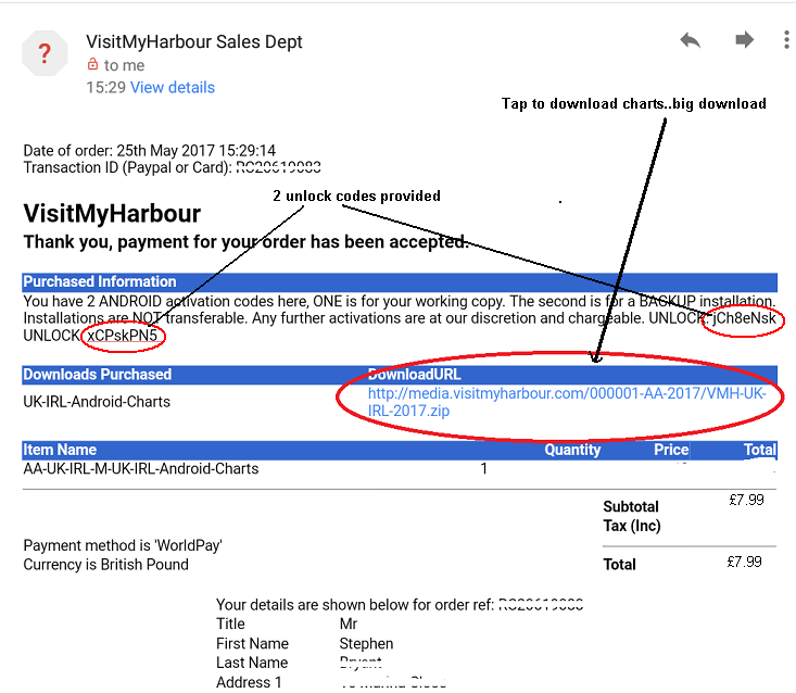
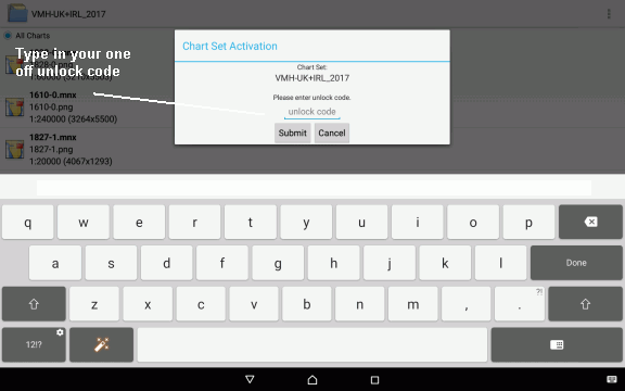
Note 2 unlock codes, and download link for the charts. Download chart set. Save this email carefully. Write down carefully the first unlock code, you'll need it shortly.
Checklist:
Next:
OK let's go... Start Marine Navigator
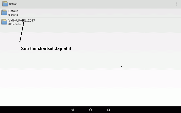
1.
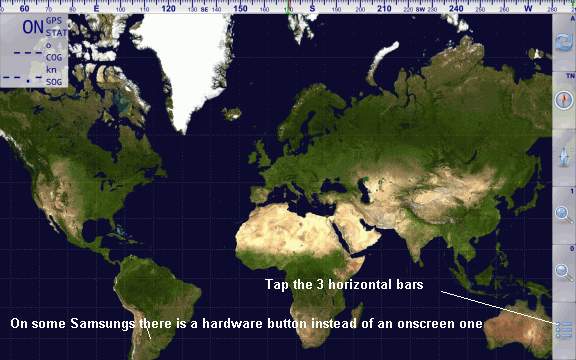
Choose IMPORT
2:
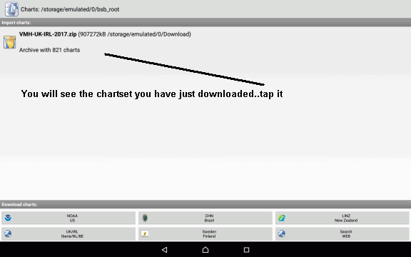
Don't see the chartset where it should be above ? Check it's in your "Downloads" folder
3:
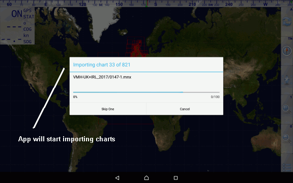
This step can take a few minutes.
4:

5:
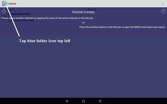
6:
At this stage you are "pointing" the app at the chart set
7:
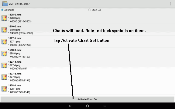
8:
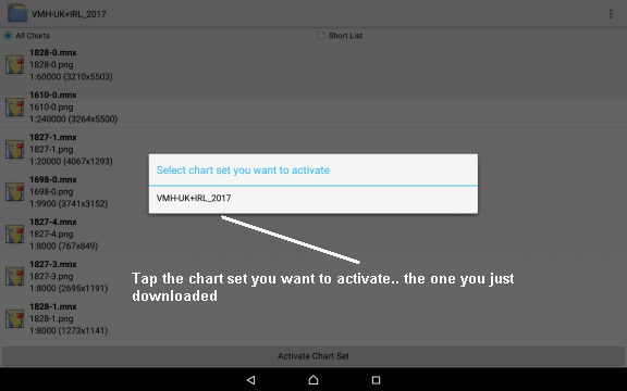
9:
10:
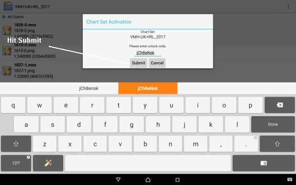
Type in the unlock code you wrote down earlier. Submit.
11:
12:
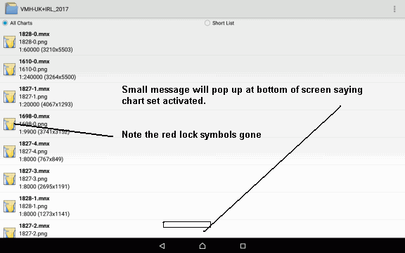
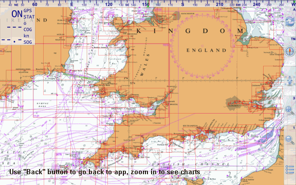
After the stage above, charts are unlocked... use the "back" button to return to app main screen. Zoom in to see charts.
Note: Just because everything is automated, does not mean you are on your own if things don't go smoothly. We are UK based and easy to get hold of on weekdays, by phone, or email/contact form anythime.
Our phone 01983 293757 M-F 11-4
Or use the Contact ButtonWe are Trading Standards checked and approved since 2011
Short video shows the import and activation process.
End User License: Charts for Marine Navigator Android app by download (version 2017-AA.1)
This is an agreement between YOU (the original purchaser of Android Charts by download) and VisitMyHarbour of 36 High St Cowes PO31 7RS. By accessing these Charts whichever format they are supplied in, you are deemed to have agreed to the terms of this license. If you do not agree with the terms of this license do not purchase, install or activate the chartset.
NOTICE 1: These images have been produced for “Charts for Marine Navigator Android app by download” and should not be used for any other purposes. The UK Hydrographic Office (UKHO) and its licensors make no warranties or representations, express or implied, with respect to this product. The UKHO and its licensors have not verified the information in this product or quality assured it. British Crown Copyright, 2017.
NOTICE 2 « Aucun service hydrographique officiel n’a vérifié les informations contenues dans ce document et ne peut être tenu responsable de la fidélité de leur reproduction ou de toute modification ultérieure. La possession de ce produit dérivé n’exonère pas de l’obligation d’utiliser les documents nautiques appropriés prévus par les règlements nationaux ou internationaux ».
« Ce produit intègre des données © SHOM – 12/2016 – reproduites avec l’autorisation n° 6/2015 »
"No official Hydrographic Office has verified the information contained in this document and can not be held responsible for the accuracy of reproduction or any subsequent amendment. Possession of this derivative does not exempt you from the obligation to use appropriate nautical documents required by national or international laws".
"This product incorporates data © SHOM - December 2016 - reproduced with authorization No. 6/2015 "
NOTICE 3 Instituto Hidrográfico de la Marina (IHM) and the UK Hydrographic Office (UKHO) make no warranties or representations, or implied, with respect to this product. The Instituto Hidrográfico de la Marina (IHM) and the UKHO have not verified the information within this product or quality assured it.
The use of this product for the planning and execution of passages will not meet the requirements of SOLAS
This applies only to Spanish harbour chartlets/inserts/plans prepared from S57 vector data (if they are included) supplied by IHM: “THIS PRODUCT IS NOT TO BE USED FOR NAVIGATION”
NOTICE 4
This product consists ONLY OF A LICENSE to use the software/data you install/use in the manner specified below, and this license is FOR THE ORIGINAL (NAMED) PURCHASER ONLY. The license is NOT transferrable to 3rd parties. The software and data (but not any free or open source software if provided) remain the property of VisitMyHarbour and must be returned if requested.
2. Allowable purposes:
Chart Images: As an aid to navigation; training; simulation; and planning purposes. Due to the inherent unreliability of non-purpose-built computer equipment in a small craft environment, These electronic charts MUST NOT BE USED AS A STAND ALONE NAVIGATION SYSTEM. This product must always be used in conjunction with with official and updated paper charts and publications.
Programs that can use these charts: Your terms and conditions for using these programs should be studied when you install them. Disclaimer: VisitMyHarbour have no control of these 3rd party programs or their functionality. VisitMyHarbour are only responsible for the charts and have satisfactorily tested them within Marine Navigator (Android).
Chart Data:
Expiry and Replacement: You are licensed to use this package for the allowable purposes for one year from the date that you purchased it. Any Android installations must done within 12 months of purchase. Charts do not stop working, but must not be used in connection with navigation after 1 year of purchase. The charts are normally stamped in the bottom right hand corner with the date of issue. You are responsible for consulting notices to mariners and any noting any updating required.
Updated Chart packages are released from time to time (at a minimum annually, see website for details). Purchasers of this Android only package may be given a chart update within the first year of purchase.
Installation: You are licensed to install these charts on a maximum of 2 Android devices, within the first year of purchase. 2 unlock codes are provided, one for working, and one backup. Installations are not transferable between devices.
You will lose your chart installation in the following circumstances:
1: You do a "Factory Reset" of the Android device
2: You change the Android operating system
3: You break, lose, damage the Android device
In exceptional circumstances (only within the first year of purchase and at our discretion) , we can manually provide ONE extra emergency activation code. There is a flat charge of £10 for this irrespective of the chartset involved.
Use: It is forbidden to use this product on more than one device at any one time with the following (useful) exception: You are allowed to install a remote monitor/navigation station, for example in the cockpit. PROVIDING THAT: it cannot work independently of the host machine and is within 300 feet.
Printing: You may be allowed to print A4 chartlets, (by taking a screen-shot on Android), but these are NOT FOR NAVIGATION and for your own personal use only.
Intellectual Property Rights:
All Intellectual Property Rights contained in this product are owned by or licensed to www.visitmyharbour.com. No Intellectual Property Right contained in the product is intended to, and shall not be deemed to, transfer to any person who uses the it. All chart data used in these Unified Charts are Crown Copyright 2017, or copyright SHOM 2017 You are forbidden to copy, pass on, or distribute (in electronic or paper form) any Chart images or data. You are forbidden to attempt to decompile or otherwise interfere with any encryption systems, programs, or content included in this product.
Acknowledgements:
This product has been derived in part from material obtained from the UK Hydrograpic Office with the permission of the UK Hydrographic Office and Her Magesty's Stationery Office and the following authorities :
United Kingdom
.Aberdeen Harbour Board
.Argyll & Bute Council
.Associated British Ports – Ayr & Troon
.Associated British Ports – Barrow
.Associated British Ports – Cardiff & Barry
.Associated British Ports – Fleetwood
.Associated British Ports – Garston
.Associated British Ports – Humber
.Associated British Ports – Ipswich
.Associated British Ports – King’s Lynn
.Associated British Ports – Lowestoft
.Associated British Ports – Newport
.Associated British Ports – Plymouth
.Associated British Ports – Silloth
.Associated British Ports – Southampton
.Associated British Ports – Swansea & Port Talbot
.Associated British Ports – Teignmouth
.Belfast Harbour Commissioners
.Blyth Harbour Commission
.Brightlingsea Harbour Commissioners
.Cattewater Harbour Commissioners (Cattewater, Plymouth)
.Chichester Harbour Conservancy
.Clydeport Operations Limited
.Corporation of Trinity House
.Cowes Harbour Commission
.Cromarty Firth Port Authority
.Dart Harbour and Navigation Authority
.Dover Harbour Board
.Falmouth Harbour Commissioners
.First Corporate Shipping Limited (Bristol)
.Folkestone Harbour Company (Folkestone)
.Forth Ports plc
.Fowey Harbour Commissioners
.Fraserburgh Harbour Commissioners
.Gloucester Harbour Trustees
.Great Yarmouth Port Authority (Great Yarmouth)
.Hampshire County Council (Hamble, River Hamble)
.Harwich Haven Authority
.Heysham Port Limited
.Highland Council Harbours Authority (Gairloch, Helmsdale,
Kinlochbervie, Kyle of Lochalsh, Lochinver, Portree & Uig)
.Imerys Minerals Ltd (Par)
.Inverness Harbour Trust (Inverness, Inverness Firth)
.King's Lynn Conservancy Board
.Langstone Harbour
.Larne Harbour Limited
.Lerwick Port Authority
.Littlehampton Harbour Board
.Londonderry Port and Harbour Commissioners
.Lymington Harbour Commissioners
.Manchester Ship Canal Company
.Mersey Docks & Harbour Company (Mersey, Liverpool, Birkenhead)
.Milford Haven Port Authority
.Montrose Port Authority
.Neath Port Authority
.Newhaven Port and Properties Limited
.Northern Lighthouse Board
.Orkney Islands Council
.Padstow Harbour Commissioners
.PD Teesport
.Peel Ports Medway (Port of Sheerness Ltd)
.Peterhead Port Authority (Peterhead Bay, Peterhead Harbour)
.Poole Harbour Commissioners
.Port of Boston Limited
.Port of Cairnryan Limited
.Port of London Authority
.Port of Mostyn Ltd
.Port of Sunderland
.Port of Tyne Authority (Tyne)
.Port of Wisbech Authority
.Port of Workington
.Portland Harbour Authority Limited
.Ports of Truro & Penryn
.Portsmouth Commercial Port
.Salcombe Harbour
.Scrabster Harbour Trust (Scrabster)
.Seaham Harbour Dock Company
.Shetland Islands Council
.Shoreham Port Authority
.Stena Line Ports Limited (Fishguard, Fleetwood, Holyhead, Stranraer)
.Teignmouth Harbour Commission
.Thanet District Council (Ramsgate)
.Torbay Council Marine Services (Tor Bay; Torquay, Brixham,
Paignton)
.Torridge District Council (Bideford)
.Ullapool Harbour Trustees
.Warrenpoint Harbour Authority
.Weymouth & Portland Borough Council
.Whitstable Harbour
Channel Islands
· Jersey Harbours
· States of Alderney Harbour Authority
· States of Guernsey Harbour Authority
Isle of Man
· Isle of Man Harbours Division
Republic of Ireland
· Bantry Bay Harbour Commissioners
· Commissioner of Irish Lights
· Drogheda Port Company
· Dublin Port Company
· Dun Laoghaire Harbour Company
· Galway Harbour Company
· Iarnrod Eireann – Rosslare Europort
· Kinsale Harbour Commissioners (Kinsale)
· Port of Cork Company
· Port of New Ross
· Port of Waterford Company (Waterford)
· Shannon Foynes Port Company (River Shannon, Limerick, Foynes)
· Wicklow Port Company
“This product has been derived in part from material obtained from the Instituto Hidrográfico de la Marina and the UK Hydrographic Office with their permission.”
©Instituto Hidrográfico de la Marina, 2017. All rights reserved
“This product has been derived in part from material obtained from the Instituto Hidrográfico of Portugal and the UK Hydrographic Office with their permission.“
“© Copyright Instituto Hidrográfico of Portugal, 2017. All rights reserved.“
“This product has been derived in part from material obtained from the Netherlands and UK Hydrographic Offices with their permission.”
“© Copyright Netherlands Hydrographic Office, 2017. All rights reserved. “
"This product has been derived in part from material obtained from the Vlaamse Hydrografie and the UK Hydrographic Office with their permission.”
“© Vlaamse Hydrografie, 2017 . All rights reserved. “
© SHOM - January 2017 - reproduced with authorization No. 6/2015
Contact Details for VisitMyHarbour.
VisitMyHarbour
36 High St
Cowes
PO31 7RS
00 44 (1)983 293757
www.visitmyharbour.com