

Pilotage information.. on your phone
Contacts
Tobermory Harbour Association 01688 302876 or 07917832497 VHF #68
Harbour Garage (for diesel) 01688 302103 (used to be Mackay's)
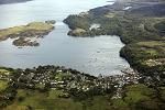
Tobermory is an extremely popular harbour in the summer; the entrance is free of dangers and it is well sheltered from just about all directions although there can be a gentle set into the marina pontoons which can keep some boats in continuous movement. This movement can be quite severe in strong NE winds when some commentators have described the conditions as "untenable"; you would certainly be in for an uncomfortable night in a NE gale.
Although there is evidence of early habitation in this area, the town of Tobermory is a fairly recent development, building having started here at the end of the 18th Century to promote the fishing industry which never took off and for a short time the only industry here was the harvesting of kelp.
In the mid 19th century Tobermory became what it is today, a tourist town. This was boosted by Mendelssohn’s Hebrides Overture and the publicity surrounding Fingal’s Cave on the island of Staffa. Queen Victoria visited here in the Royal Yacht in 1847 and the die was cast - Tobermory is now one of the “must see” destinations on the West Coast.
The Tobermory Harbour Association is an independent organisation and they seem to have “got it right”. They charge no more than any other marina on this coast and throw in the shore power with the mooring fee. It’s a slick operation as most people only stop for one or two nights on the way North and West or similarly on the way home so it’s a constantly changing neighbourhood. And they have it down to a tee.
Ashore the locals are welcoming and there is not a feeling of being fleeced as quickly as possible!! As well as this, as it is not a run down fishing village desperately hanging on to its “old traditions” with boarded up shops and warehouses; it is what it has always been - a fairly genteel tourist town, well maintained and easy on the eye.
Tobermory's website is at http://www.tobermoryharbour.co.uk/
There are no problems in the approach through the main NE channel apart....
.... from the fact that you are sharing it with the ferry traffic. This is not a problem as they obey the collision regs religiously - you should too! A wise mariner would have the sails stowed and warps & fenders rigged as required because you are likely to identify a favourable mooring vacancy at the last minute with not much room to manoeuvre.
To make your approach to the pontoon area the old designated "freeway" along the North side of the bay abeam the Calmac Ferry has been scrapped. There is a new preferred route in marked by Port and Starboard marks due East of the Pontoons; this keeps you well clear of the Calmac Berth and any Cruise boat tenders using the new North Pontoon. Mind you the tendency is to come through the entrance and then weave your way through the moorings - but you should be aware of the harbour's preference.
On the West corner of the bay the THA has pontoon berths for.....
.... about 50 boats (though the inner berths are only suitable for shallow draft boats) and a further 25 blue visitors buoys to the South east of that. Without that area there is no objection to you dropping your pick anywhere else in the bay though you should avoid the marked fairway to the central pier and the turning circle off the CalMac pier.
If you can take the ground there is just room to anchor in the small cove between the marina slip and the central pier (use a tripping line); otherwise you can find room in Acarseid Mor on the NW side of Calve Island (but beware the mussel farm and the reef at the entrance), in the narrow passage (Doirlinn) between Calve Island and the main island or in Aros Bay at the Southern end of the bay (not too much room here today because of the fish farm). Antares has charts of both of these anchorages
We have reproduced a schematic chart of the bay (by kind permission of the THA) so you can see what’s available close in. The Visitor’s buoys are blue with yellow pick up float and you should not use the Central hammerhead as that is used for refuelling.

Update 2019. They have added a new pontoon (called the "Northern Arm") which we show in our gallery - basically it's parallel to the other pontoons and lies to the North of the other two. Its for commercial use. The fuel berth is still what is now the central hammerhead
Pricing is a mixed feast but basically on the pontoons it's £17.00 up to 6 metres and then £3 per metre extra after that which includes shore power. A swinging mooring is roughly £15 per night and anchoring within the designated anchoring areas is free.
There is shore power and water for every pontoon berth all of which is included in the mooring fee. Ashore in the THA building there are showers (coin op), toilets and a laundrette (again coin op). You need a code to get into the ablutions or you can pop 20p in the slot.
Diesel is available on the refuel berth (north hammerhead) between 0830 and 1730 at the height of the summer (which is why you might conceivably need to use the Doirlinn Narrows to save time!) - thus a late arrival and early departure plus a refuel are not an option. If you do need to refuel outside the hours you could give the Moorings manager a call on his mobile well in advance - but I wouldn’t bank on it. Petrol and gas/gaz you’ll have to get from the Harbour Garage, just a hundred yards from the marina gate.
There is a well equipped chandlery just past the central pier towards the CalMac terminal.
For the rest there is a Co-op (in premises way too small for the amount of stock they carry), a baker and a chemist.
We mentioned at the outset that Tobermory is primarily a tourist destination and as such virtually all tastes are catered for (though I searched in vain for Para Handy’s “highchinks”) One thing though, everywhere is busy so you should try to book in advance.
The Mishnish is a favourite watering hole for yachties.
There is a very good website covering the facilities available here
http://www.scottishanchorages.co.uk/#/tobermory/4533048971
Copyright 2023 www.visitmyharbour.com