

Pilotage information.. on your phone
Contacts:
Carrickfergus Marina VHF 80 028 9336 6666
Carrick Marine Projects 028 9335 5884
Carrickfergus Harbour and Marina is situated halfway up Belfast Lough on its northern shore. Both the harbour and marina are administered by Carrickfergus Borough Council which does not offer visitor berths in the harbour; thus all visiting yachts will be directed to a berth in the marina on initial contact with them on VHF 80/M2.
Carrickfergus has a long and fascinating history and was the principal town in Northern Ireland before Belfast was established. The castle which dominates the harbour here was built by the Normans in the late 12th Century and has been fought over ever since. Belfast Lough was originally called Carrickfergus Bay and the Borough existed as a separate county in Ireland for a considerable period after Belfast became the capital.
The marina here is a top of the range facility offering 320 berths and in 2022 is charging £3.20 per metre per night for visiting boats but this does include the use of the shower block. It has numerous prestigious awards and is proud of its service to customers. The "official" marina website can be found at the link below but don't bother, there's more on this site as their site is the standard Council effort.
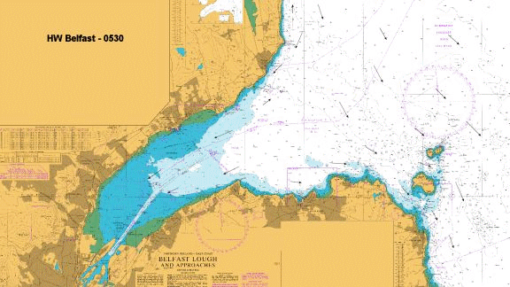
Tidal information:
As can be seen from our set of chartlets for the streams in Belfast Lough (see “More Information” below).....
.......the tidal streams in Belfast Lough can be quite varied. The chartlets show the general direction of the streams throughout the tidal cycle but should be not used as a measurement of exact direction or rate for navigation. Any transit of these waters must be carefully planned with regard to the tides.
Within the area under the control of Belfast Harbour the streams are not too strong and go with the High and Low waters at Belfast. Beyond a line from Grey Point to Carrickfergus they diverge (or converge) from the North and South flows in the North Channel. Tidal Diamond B on AC 1753-0 is right in the middle of this convergence and not indicative of what’s going on around the edges. Note from that chart that, in the vicinity of Grey Point to the West of Bangor the flood springs diverge to give a counter current of unspecified strength towards Bangor.
The flows in the vicinity of the Copeland Island group are often contrary to the main flows in the Lough and the North Channel, reach strengths of up to 3.5 kts and can set up races and overflows where they meet. Off the NE corner of Mew Island there are overfalls on the ebb and flood tides - set NNW and SSE with the tides. It should be noted that as a result of these contrary streams the direction of buoyage within this channel is NW with the flood into the Lough not, as could be expected, SSE with the flood into the Irish sea.
Update Dec 2021 New SHM (QG) in Position Lat: 54° 44.125’N Long: 005° 41.606’W off Cloughan Pier
Approach:
The marina should be contacted for berthing instructions on VHF channel 80 before entering. Page 16 of the Marina Handbook has a diagram of the berths and a wise skipper would have some sort of copy of that to hand before starting the approach as the berth signage is not that obvious. We have also provided that diagram in our picture gallery top right on this site.
The approach light on the Western pier head of the marina makes the approach to the marina fairly simple. In daylight there are triangular lead in marks; they are a little obscure but the beacons on the pierheads are easily seen. The waypoint is in the central white arc of the approach beacon and the marina can be accessed on a bearing of 310(T) from there. The entrance to the marina will not be seen until it starts to open in the latter stages of the approach and once abeam the east pierhead a turn to starboard should be initiated to pass through the middle of the entrance prior to turning to port to enter the marina. The marina lanes are nice and wide (see photos) but an easterly wind can sweep through here so full moorings including outside springs should be considered.
The Marina advises that although every effort is used to maintain the depth in the approach channel it is subject to the shifting sands from the Carrickfergus bank to the west of the channel. A deep draught boat should stick as close to the channel as possible and consult the Marina on the state of the dredge before beginning an approach.
As has been said all visiting boats are moored in the Marina.
If you have seen a plan of the Harbour (as opposed to the Marina) on their website you will have noticed that they provide a "visitors pontoon" at the North end of the Optimist Pontoon; this is not for use by visiting cruisers but a waiting pontoon for regular berth holders in the Inner harbour which is constrained by depth.

The charges in the Marina in 2022 are £3.20 per metre per day which is inclusive of VAT and showers. They also do BOGOF if you pay upfront for one night. Electricity is a pound a night
Everything the yachtsman could require is available at Carrickfergus and most are immediately next to the Marina itself. Diesel is available at their fuel pontoon but petrol must be obtained in cans from the nearby filling station (‘twas ever thus!!).
There is a pump out station and facilities for chemical toilets. If winter storage is required they have a 45 tonne travel hoist, slipway (in the harbour) and available hardstanding.
Carrick Marine Projects provide every repair service going and can even make you new cushions if you want!! It should be noted though that only “contracted” services are allowed in by the marina. The other chandleries and marine services that were here have all shut down.
Tidal flow animation, Belfast Lough.
There are pubs, restaurants and fast food outlets clustered around the marina and so it is not necessary to plod very far for what one needs. Behind the flats on the quay there’s a large Sainsburys and a multiplex Cinema along with another group of fast foods.
For pubs see this website:
Carrickfergus pubs and bars; pubs in Carrickfergus, County Antrim
Restaurants
Restaurants & Places to Eat in Carrickfergus 2022 - Tripadvisor
The marina is also the home of the Carrickfergus Sailing Club which also has showers, a bar and restaurant which visitors are welcome to share.
In short Carrickfergus is an ideal place for the cruising sailor to stop for a while and relax.
Copyright 2023 www.visitmyharbour.com