

Pilotage information.. on your phone
Contacts:
Belfast Port Control : VHF Channel 12 (c/s " Belfast Harbour Radio" tel 02890 553504)
Belfast Port Operations tel 02890 553013
Abercorn Basin Marina mob 07760 994176
Belfast has great plans for these docks as far as the marine leisure business is concerned. They have already installed pontoons with 40 berths in the Abercorn Basin which is on the South side of the docks before the Lagan Bridge and plan to increase this to 200 in the future. In the spring of 2015 there are still just the 40 berths. This has eincreased to 85 in 2021
This is part of the re-development of the area known as the Titanic Quarter and will eventually provide museums, accommodation, restaurants, retail outlets etc; the show piece of the site will be the Titanic visitor centre.
This is a massive project that has altered the face of that corner of the docks as you can see from the new picture in our gallery. As you can also see from that picture the builders yard of two or three years ago has been transformed and the Titanic Visitor Centre is now up and running. What is beginning to emerge is an upmarket facility within 10 minutes walk of the centre of Belfast and will eventually have all the facilities you would expect in a city marina.
Although it is intended to make the River Lagan eventually accessible to leisure craft it should be noted that the clearance beneath the Lagan Bridge, just upstream from the Abercorn Basin, is believed to be about 8m above chart datum (MHWS is 3.5m) and the proposed Lagan Weir Lock will not change that so unless a skipper is prepared to lower his masts the limit of navigation will be the Lagan Road Bridge. Some publications list a post of River Manager; this gentleman deals with the Lagan River above the Lagan Weir; all enquiries about the Abercorn basin should use the number for the Belfast Port Operations above or the new mobile number for the Marina office.
Regulations for use of the Port are numerous and can be found on their website at:
https://www.belfast-harbour.co.uk/port/marina/guidance-to-port-entry-for-recreational-users
Much of it is common sense e.g. radio contact on Channel 12, sails must be down, no anchoring, but there are others which might not be e.g. no dinghies to be launched, no sight seeing whilst transiting the Port, so it is essential that the visiting yachtsman has a look at those regs before passing the Fairway buoy inbound.
Update July 2022 We used to advise that there is no fuelling on the pontoons. They appear to have changed that and say that you have to refuel on the "Fuelling pontoon and vacate that pontoon once you have finished fuelling". They maintain the right to declare portable containers as "unsuitable" so check with them before you fill your containers at the local garage.
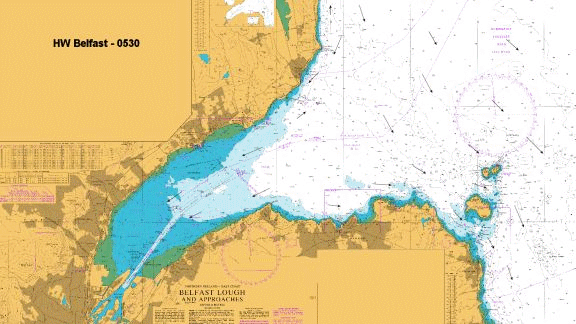
The approach is made from the Fairway Buoy in the middle of Belfast Lough. It is a requirement of Belfast Port Control that, if you are going through the docks to the visitors berths, they are contacted on Channel 12 two hours before (or as soon as reasonably practicable) the boat reaches the Fairway buoy or the entry point to the buoyed channel. That, for most yachts, is a good way out; around the Isle of Muck from the North, Donaghadee from the South and just over halfway from Scotland if from there. Once in the buoyed channel it should be treated as a narrow channel as stated above. It should be noted that once in the channel the Port Code of Practice insists that you be under motor with the sails down; that doesn’t mean to say that you cannot clew up somewhere in the vicinity of the No10, 11 or 12 buoy and join the channel there; just make sure the Port Control is aware of that (they have most of the Lough under radar surveillance anyway and will probably have identified you long before then!)
We have included an animated diagram of the tidal flows around Belfast Lough in the "More Information" section to assist in your navigation to the Fairway Buoy
Once in the buoyed channel it is simply a matter of following that channel into the docks, keeping a weather eye out for large ship movements and listening on #12 for indications of ships either about to leave outbound or overtaking you inbound (which they will be as the speed limit is 6knots). You should advise Port Control as you pass the N012 buoy.
Abercorn Basin is on the port side as you pass upriver about 2.5 miles up from the entry to the docks. It’s easily identified as it has the Odyssey Complex (tall curved white building; see our photo) on its upstream side.
T here is absolutely no anchoring in the Victoria Channel or the Docks. The only berths for visiting yachts are now in the Abercorn Basin. They now have 85 berths for boats up to 25m and 4 metres draft but if you intend taking a boat of over 20 meters you should give Port Operations a ring before setting out.
Berths are allocated on a first come first served basis and you should contact Port Operations (number above) to enquire about availability.
Belfast Harbour | Marina (belfast-harbour.co.uk)
NB. The security code for the pontoon gates and the new amenities building is on the ticket given out by the Pay Machine – don’t lose it!!
You should note from the Visitors Code of Practice document that there are extra rules for behaviour in the marina over and above normal marina etiquette; for a list of these see "Further Berthing Information" below
The mooring charge includes free access to the water but you have to pay for shore power on the pontoons. They intend using a website to collect for shore power. Toilets and showers are now available in the new amenities block which is accessed by the same code as for the gate. In addition the laundry facilities are included in the mooring fee!!
There is WiFi available in the local cafes but the marina does not supply a link.
If you walk along the side of the river towards the weir under the Flyover system until you get to the Bridge End and turn left there is a filling station a couple of hundred yards up the road . Remember that the cans must meet the Marina standards so check before you fill them. You may also have to move your boat to the refuelling berth to fill her up.
Diesel may be purchased from the Harbour from 0900 t0 1600; contact Port Operations by phone (number above) for details
There was a chandlery (McCready’s) on the other side of the river but that is long gone. There is a sail maker/dodgers/covers maker/repairer called Tedfords on Ormeau Road (about half an hours walk) but they do NOT do any chandlery (tel 02890 326763)
This animated diagram shows the tidal flows around Belfast Lough
Belfast is the capital of everything Northern Irish so there is something to suit every taste here. A useful guide to the pubs can be found at:-
http://www.beerintheevening.com/pubs/results.shtml?l=Belfast
and
Copyright 2023 www.visitmyharbour.com