

Pilotage information.. on your phone
Contacts: HM 01667 456008 mob 07851635088 (probably best)
The harbour here is another of the Thomas Telford creations on this coast as is the small development of fishermen’s cottages next to it. The rest of the town has developed in isolated groups; at first there were the fishermen in “Fishertown” by the harbour and, inland from that the farming community and finally at the West end of the town the well heeled visitors and residents who built themselves impressive villas and “big hooses.”
The communities were separated not only geographically but also by culture and language; the fishing community spoke Gaelic and the “posh end” Lowland Scots whilst the farmers spoke their own version of Scots. Nowadays it is one community, albeit with the wealthier folk living in the West end, and, if you have visited other ports to the East of here, you will notice that the dialect has softened from the broad Doric of Peterhead and Fraserburgh to the accent here which is beginning to show the influence of the West Coast.
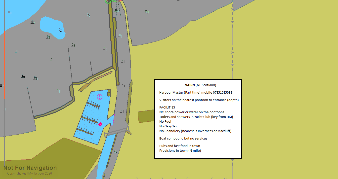
The harbour has been formed by enclosing the River Nairn and dredging out the harbour itself on the west bank of the river. The banks of the Nairn have been extended out into the Firth to form high “training” walls which has constricted the flow of the river and allowed it to scour out the channel we see today. That channel is not of uniform depth; outbound, the river is deeper on the west side as it passes the harbour entrance and then continues in a straight line to establish itself down the eastern side of the channel, leaving the West side very shallow and rocky. The marina basin is said to be dredged to a meter below LAT but that should be taken with a pinch of salt; if you are fin keeled with a 1.5m+ draft you would be well advised to contact the HM on his mobile for information on the depths.
A word of caution here; the UKHO chart of the close inshore waters here was last updated between 1958 and 1976 and has an overprinted label warning that depths "may be less than charted..." and in this case you're not talking depths but drying heights!!
From the East you should remain a good mile to a mile and a half off the visible shoreline...
..... if not more; apart from anything else the gentle shelving of the bottom here can set up a swell quite far out so the further out you are the more comfortable it will be; especially if the sea is from the North or North East. When you have passed abeam the Culbin Forest the shore line changes to sand dunes which terminate in a caravan site and by the time you can see that, the light house on the end of the East pierhead will be very evident but don’t make straight for it at that stage; stand on along the coast until you have the light house on your port beam and the Cromarty Firth on the starboard beam. The channel should be open by then on a bearing of about 150T, turn and run in on that bearing with the Cromarty Firth dead astern. If you look at our Google overhead link you can actually see the deeper channel on that (until they do another satellite pass over this area which is long overdue as those on display in 2012 were taken pre 2009).
From the West, coming out of Inverness, you will have come through the South Channel on the ebb which you will have had to carry all the way from the Kessock Bridge. This will call for some very careful timing as the slack before the outbound stream at Kessock starts at about the same time as HW Nairn; you will have to maintain a SOG in excess of 6kts (it’s about 15 miles) to arrive at Nairn with enough water to enter. When Nairn comes into sight it’s about two miles long; the harbour is at the Eastern (far) end and its light house will not become obvious until you have the west end of Nairn broad on the starboard bow. Again, stand on along the coast until you have the light house on one beam and the Cromarty Firth on the other and run in from our waypoint on about 150°T
If you are coming across from Cromarty you have a similar problem to that coming out of Inverness; the high tides at Cromarty and Nairn are almost coincident but this time there is only nine miles between them which is good but the downside is that you won’t have much lift from the tidal stream.
The other thing about coming across from Cromarty is that Nairn is obvious from the moment you leave the Cromarty Firth but it stretches from the port bow to the starboard bow; the harbour is at the extreme East end of the town and don’t forget that the tidal stream will be pushing you in towards Inverness; good luck with the nav!!
Once inside the channel, stay over to the East side until you reach the ladder opposite the stone retaining embankment on the West side; you should then straight line it towards the harbour entrance (which you won't be able to see but there are some huts on the South side of the entrance which will give you some idea where it is)
They are promising a dredge in the winter of 2017/8 but the passage up will still be on the East side switching to the West side at the ladder
The likely hood is that you will be given a berth on the hammer head dead opposite the marina entrance.....
.... so you will need to hug the south side of the entrance to give you enough room to swing round to starboard and come alongside; the alternative is to come through the entrance too far to the right, attempt the turn and T-bone the pontoon!!
If you have a 2 meter draft make sure the harbour master knows so that he can put you alongside the outer wall instead of the pontoons where it will be too shallow at LW. (Mind you, it’s a muddy bottom so you’d probably be alright – some of the locals do).
 This is a Highland Council harbour so the charges are in line with their other harbours, £26.36 per night for a 10 metre boat unless you have a Rover ticket. Caution, there's only here and Helmsdale in the Highland Council Rover scheme on the East Coast. There’s no charge for electricity ‘cos there isn’t any!
You are in for a surprise here; they built a lovely marina with nice wide pontoons and fairways but did not bother with electricity on the pontoons or an amenities block ashore. There is now a water supply on the pontoons and they are awaiting anelectrician to wire in their new shore power stanchions. There are still no plans for a harbour amenities building (asnd it's probably not worth it for the number of visitors at the moment.
The HM will give you a key and the code for the Yacht Club where there are showers (coin op) and toilets.
Fuel may be obtained in cans from a garage in town but they do not have Gas or Gaz neither does the caravan site (apart from huge Propane bottles for their own use)
Plenty of shops but you’ll need your going-ashore trolley because the supermarkets are a long hike.
There is a railway station and a direct bus to Inverness Airport from here.
When I first visited this harbour it was a disappointment, there were plenty of pubs and take aways in the town but other than that it was dead. We visited mid week in July and this is meant to be a holiday resort town but, unless you play golf there was nothing.
That has changed a bit with the addition of a cafe on the harbour side and a good bar/restaurant (the Sun Dancer) on the shore adjacent to the harbour. Both have good reviews and the Sun Dancer menu looks inviting but not cheap.
So, combine a Friday evening of the "High Chinks" (apologies to Para Handy) in the yacht club and a Saturday evening in the Sun Dancer and you'd have the makings of a weekend.
Many of the shops in the town were boarded up, the Hiking/outdoor shop was having a closing down sale (lucky for me as I needed a new Gaz bottle regulator and I got their last one!); it was all a bit drab.
The Yacht Club bar is open on a Friday night so maybe that is a better time to be there.
Nairn Yacht Club 01667 453897 Sailing | Nairn Sailing Club | Scotland
Eating Out Restaurants & Places to Eat in Nairn - Tripadvisor
Copyright 2023 www.visitmyharbour.com