

Pilotage information.. on your phone
Contacts: Harbour Master VHF 16/12 mob 07816 077755
Bude has functioned as a port since the eighteenth Century but it was not until the early nineteenth Century that the canal was built to transport the mineral rich sand from the beach into the hinterland as an agricultural fertiliser. Throughout that century goods were imported from Bristol, Ireland and Wales; it has to be remembered that in those days the overland route was very rough and ready so transport by sea was much quicker. The canal remains but is no longer used for the purpose for which it was originally built and there is no longer any commercial trade.
Up until the end of the twentieth century Bude was avoided by yachts simply because of the locking fees which made a visit there totally unacceptable unless one teamed up with a flotilla and spread the cost. All that has changed, the lock gates were damaged in the late nineties and have been replaced and now this popular holiday spot has become a viable stopping off point for the yachtsman cruising on the North Cornish coast and will probably challenge the overcrowded Padstow in years to come. The town itself has long been a mecca for the surfers and has the facilities to cater for those visitors so the yachtsman will also be well catered for.
UPDATE 2021 The lockgates received further damage a couple of years ago and forced them to close the Inner Harbour but as we write in September 2021 they have repaired this damage and are about to re-open.
They are keen to welcome visiting sailors and the HM is very helpful so let us know how you get on if you drop in here.
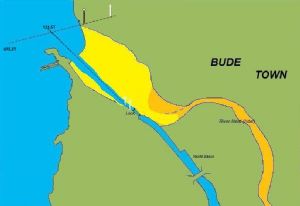
The entrance to the harbour will be described at length below but it basically lies at the south end of a long strand and is tucked in behind the rock structures which form the southern boundary of the strand. In on shore conditions the surf on the beach makes the entrance challenging and in NW conditions it is unapproachable but in Southerly to North easterly conditions the entrance is ok and the canal basin provides shelter in all conditions once attained.
Whether approaching from the North or South the final.........
......approach into Bude has to be made from the South West and about two hours either side of HW. This is a very flat piece of coastline and picking out Bude itself can be difficult; coming from the South the low cliff line ends abruptly and there is a stone tower just to the south of the Bude entrance. Three miles to the North of Bude is a group of large white satellite dish aerials which can be seen for miles and is a good point of reference for a visual approach from that direction.
Remember that you should have given the HM a ring to tell him of your arrival and should have set up two way communications with him on channel 12 in the approach; the working of the lock gates involves some considerable organisation of manpower and there needs to be a minimum depth of 2.5m in the approach for them to open the gate.
Once through the lock and into the canal, alongside berths are available to which the HM will direct you.
In 2022 they are charging £18.00 per night for all boats under 12 metres with a minimum stay of two nights . The locking in and out is included in that charge
The reason for the two night minimum is because they need to reduce the frequency of lockings to maintain the water level in the canal but how this works if there is a succession of boats visiting is not quite clear!!
At the moment Bude is so off the cruising map that a succession of movements is unlikely to occur at the moment and you will probably have the place to yourself which is a definite plus on this coast!!
The harbour website can be found at
There is water and electrical hook up (paid by card obtainable from HM if there is not already some left on the meter) at the berths and a recently built shower and toilet block.
Petrol and diesel are available in cans from a nearby filling station which has a Spar shop and also supplies Calor gas. There is a Caravan site at Poughill about a mile from the canal basin which supplies Camping Gaz. There are also a Morrisons and a Sainsbury’s in the town which are not too far away for a major shopping expedition.
Bude abounds with restaurants, pubs and fast food outlets; most of them are over the river in the main town on the North side of the canal but there is a hotel & bar close by on the South side of the canal basin.
There is a Post Office shop just round the corner from the basin for the morning papers and the Bude Tourist Information centre is adjacent to the yacht berths
Copyright 2023 www.visitmyharbour.com